The Western Boundary
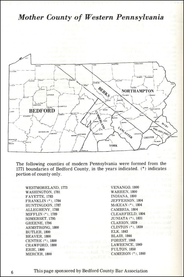
The image below is from page 6 of the 1971 Official program ~ Bedford County 1771-1971 Bicentennial.
The Act of the General Assembly of Pennsylvania enacted on 09 March 1771, by which Bedford County was erected out of Cumberland County, stated: “That all and singular the lands lying and being within the boundaries following, that is to say; beginning where the province line crosses the Tuscarora mountain, and running along the summit of that mountain to the Gap near the head of the Path Valley; thence with a north line to the Juniata; thence with the Juniata to the mouth of Shaver’s-creek; thence north-east to the line of Berks county; thence along the Berks county line northwestward to the western bounds of the province; thence southward, according to the several courses of the western boundary of the province, to the southwest corner of the province; and from thence eastward with the southern line of the province to the place of beginning; shall be, and the same is hereby, erected into the county, henceforth to be called Bedford.”
The argument was proposed by the honorable William P. Schell in 1907 ~ that all of the western Pennsylvania counties were part of, and erected out of, Bedford County. He presented his argument in his small volume The Annals Of Bedford County.
Some historians, including Mr. Schell, have interpreted the part of the description that states “thence along the Berks county line northwestward to the western bounds of the province; thence southward, according to the several courses of the western boundary of the province, to the southwest corner of the province” to mean that it stretched northwestward to where Erie is located today and then straight southward along the present-day line separating Pennsylvania from Ohio and West Virginia. How they interpret the part that states “thence southward, according to the several courses of the western boundary of the province” as the present-day vertical line is anyone’s guess.
What needs to be taken into account is the fact that the northwest corner of the present-day state of Pennsylvania was not purchased from the Amerindians until 1784 ~ 13 years after Bedford County was erected. How can it be assumed that Bedford County encompassed lands that were still owned by the Amerindians? We should acknowledge that by all of the treaties, the Euro~Americans in essence cheated the Amerindians who didn’t understand the European concept of land ownership. So to say that we purchased land is stretching the truth a bit. But even so, to assume that the Euro~Americans could ‘future-obtain’ lands ~ claiming possession thirteen years in the future ~ is really stretching the truth beyond believability. The reason is because the description in the Act of 09 March 1771 was a description based on the reality of 1771 – not of 2016 – nor of 1907 when William P. Schell stated that he would “show, definitely, that not only the above-mentioned territory was included within the bounds of Bedford County by the said Act of 1771, but that all territory embraced within the purchase from the Indians by the Commonwealth, at Fort Stanwix in 1784, included in the present counties of Beaver, Lawrence, Mercer, Crawford, Butler, Venango, Warren, Forest, Clarion, Jefferson, Elk, Cameron and parts of Allegheny, Beaver, Armstrong, Erie, Indiana, Clearfield, Centre, Clinton and part of McKean, were also included within the limits of Bedford county”. Mr. Schell attempted to establish the idea that Bedford County was the ‘mother’ county of all western Pennsylvania counties.
In 1771 the lands purchased from the Amerindians, and from which Bedford County was erected, included the 1754 ‘Albany Purchase’ and, more recently, the so-called ‘New Purchase’ of 1768. How anyone can maintain that the Province of Pennsylvania could claim ownership of the northwest corner, thirteen years before it was formally purchased from the Amerindians is astounding. That would be like Bedford County today claiming that it owns the lands southward into Allegany County, Maryland and on southward into Mineral and Hampshire Counties, West Virginia because in 2033, thirteen years from now, a treaty will be made and Bedford County will, at that future date, purchase those lands. In 1771 there was no way of knowing what other treaties would be made. Hindsight is always 20/20, but foresight is not so clear.
Schell’s argument, which is probably the same one used by other proponents of his theory, was based on the assumption that the phrase “western bounds of the province” referred to the bounds he was aware of in 1907 (which by that time included the 1784 purchase with the western line of the province fully established). His argument was also based on the assumption that in 1681 when King Charles II granted the charter to William Penn, it included all of the lands encompassed in the present-day state of Pennsylvania. That assumption might have been based on the fact that King Charles II of England believed that he held the right to claim possession of the Amerindian lands ~ purchased or not. And so King Charles II granted to Penn the lands west of the Delaware River for a distance of five degrees in longitude – but that claim of ‘possession by monarchical right’ was refuted by William Penn himself. Penn insisted that any lands that the General Assembly desired to add to the province must be purchased from the Amerindian natives by treaty. Therefore it can be extrapolated that Penn insisted that the boundaries of the province could only be defined by the boundaries of lands acquired from the Amerindians by treaty. The General Assembly followed Penn’s instructions and established new counties only within the bounds of lands actually purchased by formal treaties with the Amerindians claiming possession. (That is why some conflicts arose. The Delawares claimed ownership of some regions that the Iroquois also claimed. So the treaties had to accommodate both Amerindian factions.)
In an attempt to show how absurd it would be to disagree with him, Mr. Schell pointed out that “It may be proper to say here that the words ‘Province,’ ‘the line of the Province,’ ‘the extremity of the Province,’ and ‘the bounds of the Province’ are invariably used in all state papers as referring to the charter limits of the Province; and in no case are they used as referring to a Purchase Line, or Treaty Line, made with the Indians.” Unfortunately, Mr. Schell did not provide a source of that statement. Although the author of this essay has studied many of the documents pertaining to Penn’s charter and the provincial government of Pennsylvania, he never found any document providing the definition of the words ‘Province,’ ‘the line of the Province,’ ‘the extremity of the Province,’ and ‘the bounds of the Province’ to refer solely to the charter limits of the Province. On the contrary, as noted previously, William Penn’s actions contradicted the argument given by Schell.
Returning to the Act of 09 March 1771, the part that states: “thence along the Berks county line northwestward to the western bounds of the province; thence southward, according to the several courses of the western boundary of the province, to the southwest corner of the province” should be interpreted as referring to the north and westernmost boundary established by the 1768 ‘New Purchase.’ Only by following that interpretation does the wording: “thence southward, according to the several courses of the western boundary of the province,” make any sense. The word ‘course’ usually refers to the path of a waterway, such as a ‘river’s course.’ There exist no ‘several courses’ in the straight, vertical line that defines the western boundary at the fifth degree of longitude today. Mr. Schell completely ignored that portion of the description and offered no explanation of what was meant by it. But if the line of Bedford County was intended to follow the westernmost boundary of the lands purchased in 1768 – which would have been considered the westernmost bounds of the province three years later in 1771 – it would indeed have followed the ‘courses’ of a number of rivers ‘to the southwest corner of the province.’ They included the West Branch of the Susquehanna, the Mahoning Creek, the Allegheny River and the Ohio River. If, as Mr. Schell attempted to prove, that the present-day westernmost boundary line had been what was intended by the Act erecting Bedford County, why didn’t the description of the boundary line simply state: “thence along the Berks county line northwestward to the western bounds of the province coinciding with the fifth degree of longitude; thence due southward, to the southwest corner of the province”? There would have been no need to include “thence southward, according to the several courses of the western boundary of the province.”
Using Mr. Schell’s own logic, the southernmost boundary of the new county, instead of being stated as: “and from thence [referring to the southwest corner] eastward with the southern line of the province to the place of beginning;” ~ it should have been stated as: “eastward, according to the several courses of the southern line of the province to the place of beginning;”
One final item to take into consideration when thinking about the extent of the lands established in 1771 as Bedford County is the fact that no townships were set up within the region not purchased from the Amerindians until 1784. Mr. Schell gave a reason for that when he noted that “The reason for this course, by the court, is manifest. The territory included within the new townships was pretty thickly settled and the only Wagon road in the Province, from Carlisle to Fort Pitt, ran through this entire region, while the excluded territory, afterwards purchased by the Commonwealth in 1784 at Fort McIntosh, was a howling wilderness containing thousands of Indians and no white settlers, and was without roads. But the court made no decision that the excluded territory was not included in Bedford county; in fact the question was not raised.” Although his description of the region of the northwest corner of present-day Pennsylvania as a ‘howling wilderness’ is amusing, it really does not explain why the Court of Quarter Sessions of Bedford County would not have at least proposed township divisions for that region ~ if it, in fact, was part of Bedford County at the time. The northernmost Bedford County township of Tullileague (which included a large portion of present-day Centre County) was laid out even though it was not largely settled at the time. And Mr. Schell’s end to his statement: “But the court made no decision that the excluded territory was not included in Bedford county” is like saying “They didn’t say that they owned it, but they also didn’t say that they didn’t own it.” If a governmental entity, such as the Bedford County Court was required to list all of the places it did not have jurisdiction over, in addition to those that it did, such a list might fill volumes. Mr. Schell’s final statement on the subject that: “in fact the question was not raised” actually raises another question. Disregarding the question of why the excluded territory was ignored in 1771; what is the answer to why it was not raised through the next thirteen years? And then, in 1784 ~ after the region was formally purchased from the Amerindians, and especially on 01 April 1784, when the Pennsylvania General Assembly began to grant tracts to Continental Line soldiers as compensation for their service during the American Revolutionary War ~ why didn’t anyone from Bedford County speak up and complain that the lands rightly belonged to Bedford County and demand some sort of restitution? The Act whereby the so-called Donation Lands were to be distributed to ex-Soldiers of the Continental Line was titled: “An Act For Opening The Land-Office, For Granting And Disposing Of The Unappropriated Lands Within This State.” Neither the title nor the text of that Act acknowledged Bedford County’s jurisdiction over the region. In fact, Bedford County was not mentioned at all ~ and surprisingly, no one complained or asked for redress or compensation.
It is interesting to note that when you read the Acts by which the various counties that make up the northwest corner of the state of Pennsylvania were erected, you find that none of them claim descent from Bedford County. One would assume that if Bedford County held jurisdiction over the region, from which all of the counties in the northwest corner of the province were erected, from 1771 until its purchase from the Amerindians in 1784, when individual counties were later erected, they would need to acknowledge that fact. The title of Bedford County’s own Act stated: “An Act For Erecting A Part Of The County Of Cumberland Into A Separate County,” In 1773 another Act was passed which was titled: “An Act For Erecting A Part Of The County Of Bedford Into A Separate County” by which Westmoreland was brought into existence. A review of the Acts bringing them into existence reveal that parts of Armstrong, Centre, Clarion, Clearfield, Clinton, Forest, Indiana, Potter and Warren Counties and the whole of Cameron, Elk, Jefferson and McKean Counties claim descent from Northumberland ~ not from Bedford. Farther west, the counties of Beaver, Butler, Crawford, Erie, Lawrence, Mercer and Venango and parts of Armstrong, McKean and Warren claim descent from Allegheny County ~ not from Bedford.
Bedford County gave birth to a number of other counties, but whether the number of other counties was thirty-some or if it was only eight and parts of seven depends on whether you interpret the phrase “according to the several courses” as meaning a straight line or a wavy line.